Your cart is currently empty!
A 190 MPH Super Typhoon Is Closing In On US Territory And It’s Still Growing
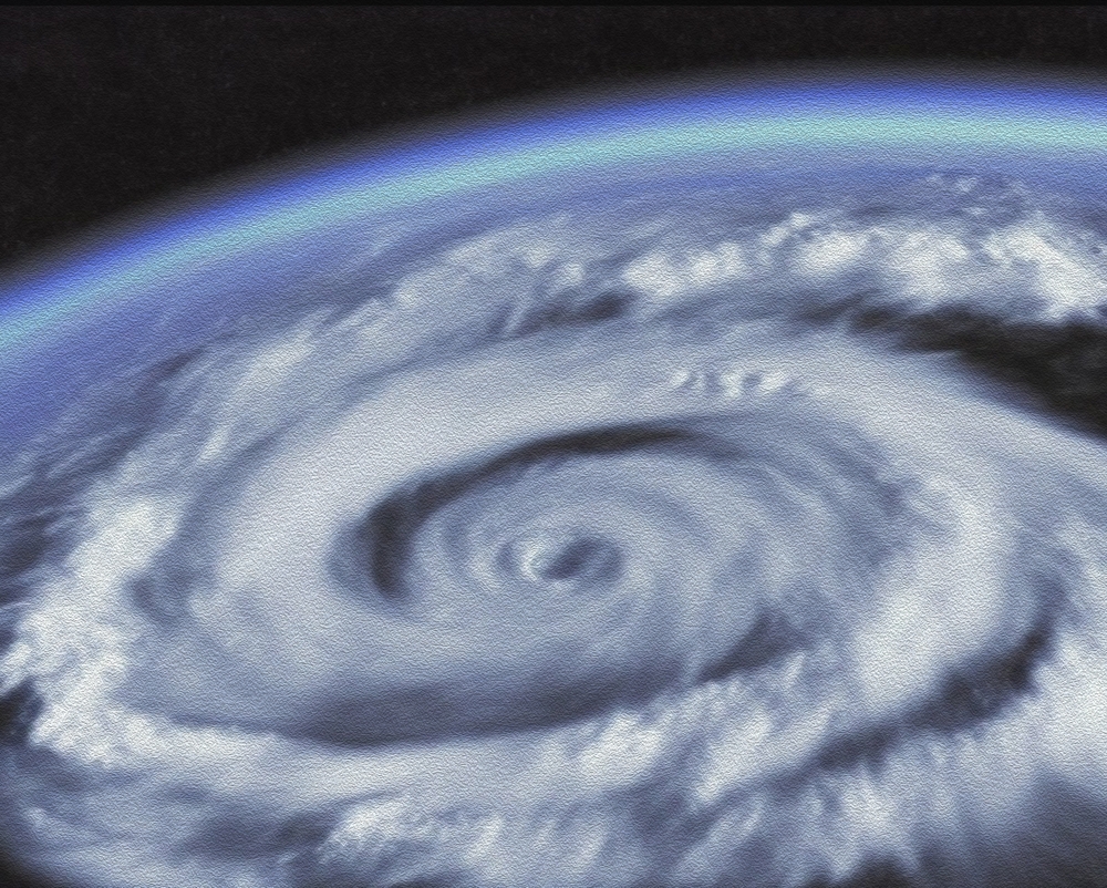
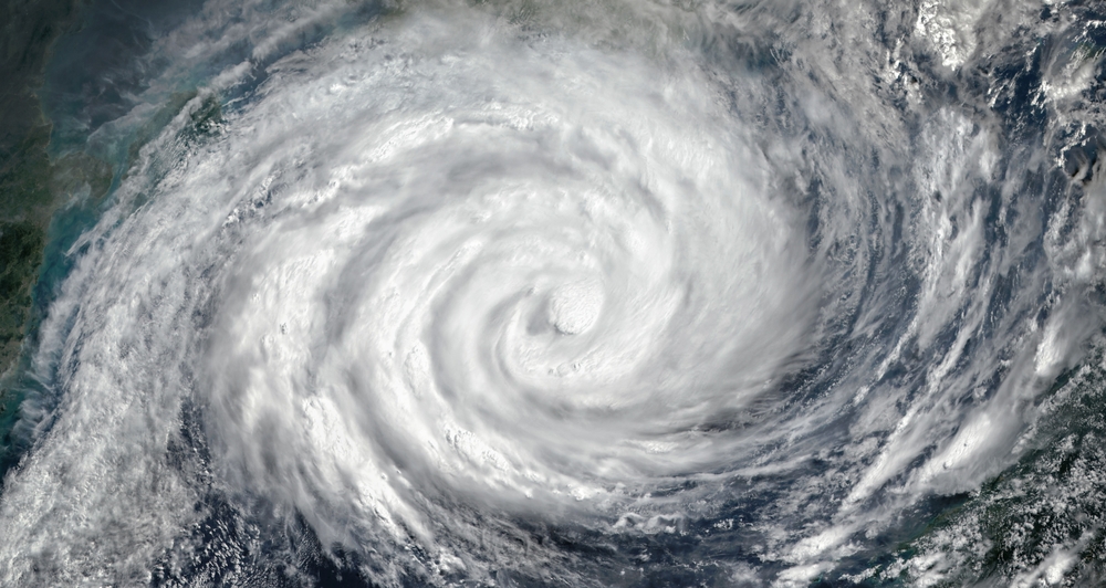
The ocean has once again shown how quickly it can shift from calm to catastrophic, as Super Typhoon Sinlaku surged across the Pacific with an intensity that has stunned meteorologists and placed entire island communities on edge. What began as a scattered cluster of disturbances over the Western Pacific evolved with alarming speed into a massive and highly organized storm system, drawing energy from exceptionally warm waters and transforming into the most powerful tropical cyclone on the planet so far in 2026. With violent winds, relentless rainfall, and a growing radius of destruction, Sinlaku has rapidly gone from a distant weather system to a direct and immediate threat to human life and infrastructure.
Contents
show
As the storm advanced toward the Northern Mariana Islands, a U.S. territory in the western Pacific, the situation became increasingly urgent with each passing hour. Residents across Saipan, Tinian, Guam, and surrounding islands found themselves preparing for a storm that officials warned could be life threatening, with very little time left to act. The U.S. National Weather Service delivered a stark and urgent message: “For those under a Warning in the Marianas, the window of time to complete preparations for the protection of life and property is very soon to close. Evacuate if directed to do so by local officials, or if your home is vulnerable to high winds or flooding.” That warning was not just precautionary, it reflected the scale, speed, and unpredictability of a storm capable of overwhelming even well-prepared communities.
From A Cluster To A Super Typhoon
Super Typhoon Sinlaku did not begin as a dramatic or headline-grabbing system, but rather as a loosely organized cluster of disturbances that formed over the Western Pacific, a region known for frequent tropical activity. In its earliest stages, there was little to suggest that it would evolve into one of the most powerful storms of the year, yet the environmental conditions surrounding it were quietly setting the stage for rapid development. As the system began to organize, meteorologists closely monitored its structure, noting that the ingredients for intensification were falling into place with unusual efficiency.
By April 9, the system had strengthened into a typhoon, and from that point forward, its intensification became both rapid and remarkable. Drawing energy from warm ocean waters and supported by favorable atmospheric conditions, the storm grew in both size and strength at a pace that set it apart from more typical systems. Within a matter of days, it escalated into a super typhoon, producing wind gusts of up to 85 meters per second, or around 190 miles per hour, which the Japan Meteorological Authority described as “violent.” This classification is reserved for only the most extreme conditions, highlighting just how dangerous the storm had become.
What makes Sinlaku particularly notable is not just its strength, but the speed at which it reached that strength. Rapid intensification events like this are closely studied because they can dramatically reduce preparation time for communities in the storm’s path. In this case, what started as a relatively unremarkable system quickly became a large-scale natural threat, illustrating how quickly conditions can change in regions prone to tropical cyclones.
Why The Western Pacific Creates Extreme Storms
The Western Pacific is widely recognized as one of the most active and dangerous regions for tropical cyclone formation, often referred to as Typhoon Alley due to the frequency and intensity of storms that develop there. One of the primary reasons for this is the exceptionally warm ocean water found in this part of the world, which provides the energy needed to fuel storm development and sustain high wind speeds over long periods. Warm water acts as the engine of a tropical cyclone, and in this region, that engine runs at full capacity.
Another critical factor is the vast expanse of open ocean, which allows storms to travel long distances without encountering land that would otherwise disrupt their structure. This uninterrupted path gives storms like Sinlaku the opportunity to strengthen gradually and continuously, building momentum as they move across thousands of miles of water. Unlike storms that quickly weaken after landfall, systems in the Western Pacific can evolve into massive and highly organized weather events before ever reaching populated areas.
In addition to warm water and open space, the atmosphere in this region is often rich in moisture, which supports the growth and maintenance of strong storm systems. High humidity levels help sustain the storm’s core and allow it to continue intensifying under the right conditions. When all of these factors come together, as they did with Sinlaku, the result is a powerful and potentially devastating storm that can impact multiple regions across a wide geographic area.

Landfall And Immediate Impact
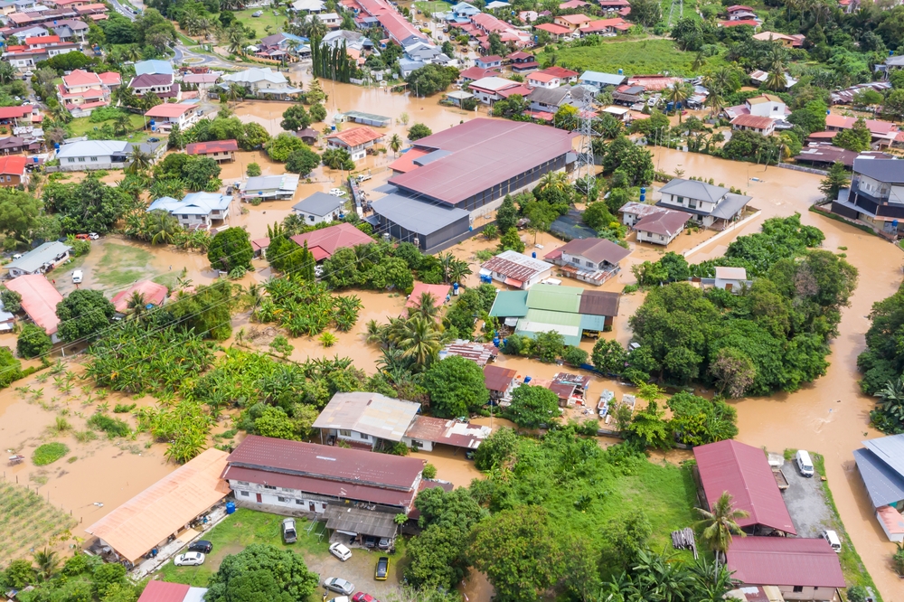
By April 14, Super Typhoon Sinlaku had reached the Northern Mariana Islands, bringing with it destructive winds, intense rainfall, and dangerous storm conditions that quickly escalated into a crisis for local communities. The eye of the storm passed directly over Saipan and Tinian, delivering sustained winds of around 150 miles per hour, placing it firmly within Category 4 intensity at the time of landfall. What made the situation even more severe was the storm’s slow forward movement, which dropped to around 5 miles per hour, prolonging exposure and increasing the likelihood of extensive damage.
As the storm lingered over the region, conditions on the ground deteriorated rapidly, with infrastructure and emergency systems placed under significant strain. Saipan International Airport recorded wind gusts exceeding 100 miles per hour for more than nine hours, with a peak gust of 130 miles per hour before the station stopped reporting data altogether. In Guam, although not directly in the storm’s core, conditions remained severe, with gusts reaching 88 miles per hour and sustained windy conditions lasting for over 48 consecutive hours.
Rainfall further intensified the situation, with totals ranging from 5 to 16 inches across affected areas, leading to widespread flooding and dangerous living conditions. Reports indicated floodwaters reaching several feet deep in parts of Saipan, while Guam experienced water levels of about one foot in some areas. Utility lines were brought down, transportation was disrupted, and residents faced both immediate hazards and the longer-term challenges of recovery as the storm continued to impact the region.
A Storm That Stands Out In History
Super Typhoon Sinlaku has drawn attention not only for the damage it caused but also for its remarkable intensity and unusual timing within the calendar year. The storm reached peak sustained winds of approximately 185 miles per hour, placing it among the strongest tropical cyclones recorded so early in the year. Typically, storms of this magnitude are associated with the peak typhoon season, which occurs between July and November, making Sinlaku’s April development particularly noteworthy.
Meteorologists have compared Sinlaku to some of the most powerful early-season storms on record, noting that it tied with Super Typhoon Hester from 1953 in terms of wind speed during this period. It was second only to Super Typhoon Surigae in 2021, which remains the strongest storm recorded during the early months of the year. These comparisons highlight just how rare and significant Sinlaku’s development has been in the broader context of historical storm data.
In addition to its wind speeds, the storm also reached a central pressure of around 890 millibars, a measurement that reflects its extreme intensity. Lower pressure values are typically associated with stronger storms, and this reading places Sinlaku among the most powerful systems observed in recent decades. Its combination of early timing and extreme strength has made it a key point of interest for scientists studying weather patterns and climate behavior.
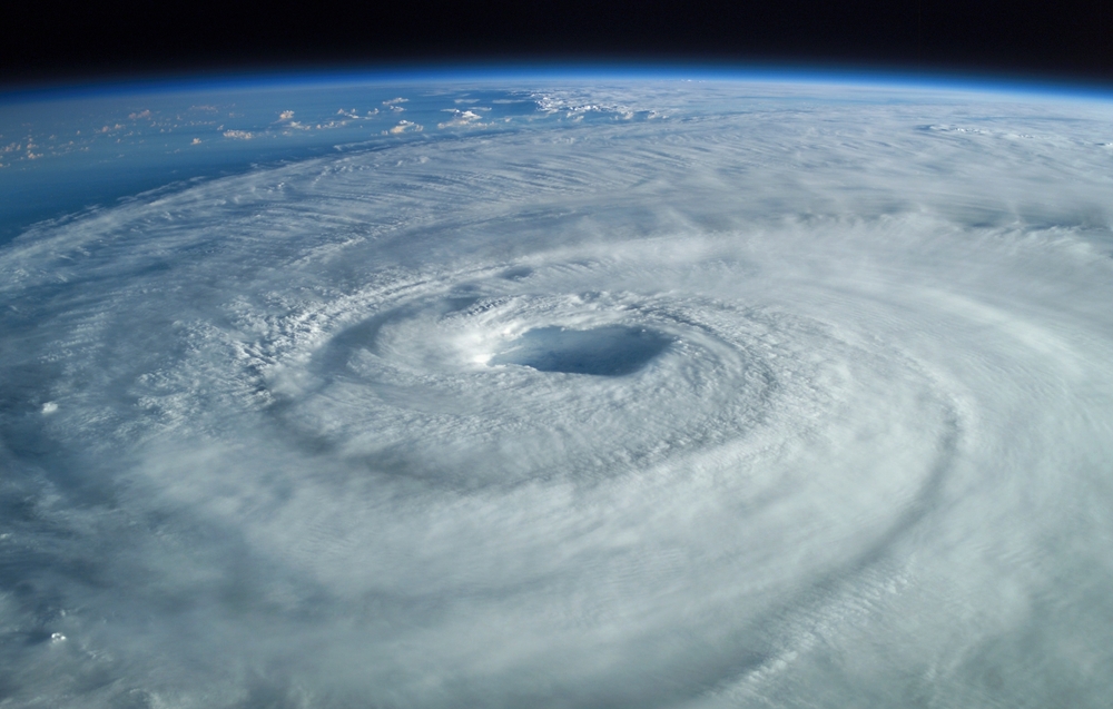
The Science Behind Its Structure
As Sinlaku approached land, it underwent a structural transformation that influenced how its impacts were distributed across the region. The storm developed a second outer eyewall, a process known as an eyewall replacement cycle, which is commonly observed in very strong tropical cyclones. This phenomenon can alter both the intensity and the size of a storm, making its effects more widespread even if peak winds fluctuate slightly.
During this process, a new outer ring of thunderstorms forms around the existing eyewall, gradually replacing the inner structure as it weakens. While this can sometimes lead to a temporary reduction in peak wind speeds, it often results in the storm expanding in size, with strong winds covering a larger geographic area. In practical terms, this means more communities are exposed to dangerous conditions, even if they are not directly in the path of the storm’s center.
In Sinlaku’s case, the development of this outer eyewall significantly increased the reach of its impacts, spreading heavy rain, strong winds, and rough seas across multiple islands. This structural change played a major role in the widespread nature of the damage and highlights how the internal dynamics of a storm can influence its overall impact on affected regions.

Twin Cyclones And A Rare Phenomenon
While Sinlaku was intensifying in the Northern Hemisphere, another powerful storm was developing south of the equator, creating a rare and scientifically significant situation known as twin cyclones. Tropical Cyclone Maila formed in the Solomon Sea and followed its own destructive path, eventually making landfall in Papua New Guinea. Reports indicated that at least 11 people were killed, including eight in a landslide and two who were struck by falling trees, underscoring the deadly nature of the system.
Twin cyclones occur when atmospheric conditions cause storms to form simultaneously on opposite sides of the equator, often originating from the same burst of wind and moisture. These systems can remain loosely connected through shared atmospheric patterns, even as they move in different directions. While this phenomenon is relatively common in the Pacific and Indian Oceans, it does not occur in the Atlantic, making it a unique feature of these regions.
The two storms also rotate in opposite directions due to the Coriolis effect, with systems in the Northern Hemisphere spinning counterclockwise and those in the Southern Hemisphere rotating clockwise. This mirrored behavior reflects the complex interactions between Earth’s rotation and atmospheric dynamics, offering insight into how large-scale weather systems develop and evolve.
A Possible Link To El Niño
Beyond the immediate impacts of wind and flooding, Sinlaku may also play a role in shaping global weather patterns in the months ahead. Meteorologists suggest that the storm, along with its southern counterpart, could contribute to the development or strengthening of an El Niño event later in the year. This process begins with strong winds pushing warm ocean water eastward across the Pacific, altering temperature distributions.
As warmer water accumulates in the eastern Pacific, it can trigger increased thunderstorm activity and changes in atmospheric circulation. This creates a feedback loop known as the Bjerknes feedback, where warming leads to more storm activity, which in turn reinforces the warming. Once this cycle begins, it can be difficult to reverse, leading to sustained changes in global weather patterns.
El Niño events can have far-reaching consequences, influencing rainfall, drought conditions, and hurricane activity across different parts of the world. The possibility that Sinlaku contributed to this process highlights the interconnected nature of Earth’s climate system, where a single storm can have ripple effects far beyond its immediate area of impact.
Warnings And The Human Response
As Sinlaku approached the Northern Mariana Islands, officials issued repeated warnings emphasizing the seriousness of the threat and the importance of immediate action. Residents were urged to stay indoors and avoid unnecessary travel, with guidance stating, “Stay indoors during heavy rain and windy conditions associated with Super Typhoon Sinlaku. The onset of damaging and potentially destructive winds will pose a deadly threat to those venturing outside.” These warnings were intended to minimize risk and protect lives during the most dangerous phases of the storm.
Preparation efforts included securing homes, gathering emergency supplies, and evacuating vulnerable areas when instructed by local authorities. For many residents, the time available to prepare was limited due to the storm’s rapid intensification, making quick and informed decision-making essential. The combination of strong winds, heavy rainfall, and prolonged exposure created a situation where even small delays could significantly increase danger.
The response from communities and emergency services highlighted the importance of preparedness and coordination in the face of natural disasters. While infrastructure damage can be repaired over time, the primary focus remains on protecting human life, and early action is often the most effective way to achieve that goal in extreme weather events.
A Reminder Of Nature’s Scale
Super Typhoon Sinlaku stands as a powerful example of the forces that shape our planet, demonstrating how quickly natural systems can evolve into events of global significance. Its rapid formation, extreme intensity, and widespread impacts serve as a reminder that even with advanced forecasting technology, there are limits to how much control humans have over nature. Events like this challenge communities to remain vigilant and prepared in the face of uncertainty.
For those directly affected, the storm represents a moment of resilience, survival, and eventual recovery, as communities begin the process of rebuilding and restoring normalcy. For those observing from afar, it offers an opportunity to reflect on the importance of preparedness, the role of climate systems, and the interconnected nature of global weather patterns. As storms like Sinlaku continue to emerge, understanding and respect for these powerful forces will remain essential in reducing risk and protecting lives.”