Your cart is currently empty!
Hurricane Erin tracker reveals seven states most at risk as experts issue deadly warning

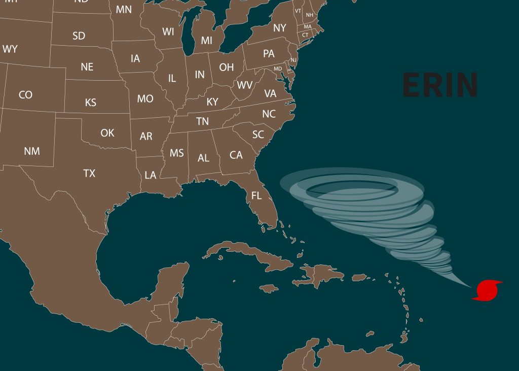
As the Atlantic hurricane season begins in earnest, Hurricane Erin has emerged as a stark reminder of the ocean’s unpredictable power. The storm, which has already demonstrated bursts of extraordinary strength, is not expected to make direct landfall, yet its reach stretches across millions of lives and seven states along the Eastern Seaboard. With winds that have climbed as high as 130 miles per hour and waves forecast to crest at 20 feet, Erin exemplifies the reality that even an offshore hurricane can disrupt communities, threaten infrastructure, and spark emergency evacuations.
Contents
show
This storm arrives at a moment when coastal regions are already grappling with rising seas, eroding shorelines, and more frequent extreme weather events. For residents of North Carolina’s Outer Banks, the Jersey Shore, and New England’s coastal towns, the warnings feel familiar, but no less urgent. States of emergency, mandatory evacuations, and flood alerts underscore the seriousness of Erin’s approach, while experts caution that the storm’s unpredictable nature leaves little room for complacency.
The Rising Threat of Hurricane Erin
Hurricane Erin has rapidly become a storm that demands attention, placing millions of Americans on high alert as it churns across the Atlantic. As the first major hurricane of the season, Erin’s development is being watched closely by meteorologists and emergency officials alike. The system has already displayed volatile behavior, surging briefly to a Category 5 hurricane with winds powerful enough to cause catastrophic damage before easing back to Category 3 strength. Even with its current sustained winds of around 130 miles per hour, Erin remains a formidable system capable of producing life-threatening conditions. Its steady northwest movement at 13 miles per hour has given coastal communities little time to relax, as forecasters emphasize that the storm’s unpredictable intensity shifts and massive size make it dangerous even from a distance.
In response to the mounting threat, North Carolina officials have taken decisive action by declaring a state of emergency and initiating mandatory evacuations for several vulnerable coastal regions. Hyde County, which encompasses Ocracoke Island, has already cleared both residents and visitors from the area. Officials warn that the storm’s impacts could soon make Highway 12, the island’s critical lifeline, impassable due to flooding and storm surge. This move underscores just how disruptive Erin is expected to be, despite its offshore trajectory. Further up and down the coastline, neighboring states are not taking chances either. Flood watches and warnings are spreading across South Carolina, Georgia, Virginia, New Jersey, New York, and Massachusetts, as officials brace for the possibility of widespread flooding, road closures, and hazardous travel conditions.
The storm’s potential to disrupt daily life extends far beyond the areas closest to its path. Although Hurricane Erin is not projected to make landfall, its sheer size ensures that its effects will reach deep inland and along hundreds of miles of coastline. Forecasters expect it to generate waves up to 20 feet high, accompanied by dangerous rip currents that threaten swimmers and beach communities along much of the Eastern Seaboard. Residents in the Tri-State Area, particularly along New Jersey’s beaches and Long Island’s South Shore, have been told to prepare for high surf, flooding, and beach erosion through the middle of the week. Meteorologists at the National Hurricane Center have emphasized that while Erin may weaken slightly in the coming days, its slow movement over the ocean means it will continue drawing up cooler water that may limit further intensification but will not reduce the storm’s capacity to cause damage.
Amid this uncertain outlook, emergency leaders are reinforcing the importance of public vigilance. In Dare County, North Carolina, emergency management director Drew Pearson made his message unambiguous when urging residents to take the evacuation orders seriously: “I encourage all residents and visitors to heed the evacuation order and take action to protect themselves, to protect their property, and to get up and leave — now.”

States in the Path of Risk
Although Hurricane Erin is not expected to make landfall, its projected path has placed seven states firmly within its danger zone. The most immediate concern lies in North Carolina, where the state government has already issued evacuation orders for multiple coastal communities. Dare County, home to popular tourist areas like the Outer Banks, has been proactive in urging both residents and visitors to leave ahead of time, a step that highlights the storm’s potential to overwhelm infrastructure. Ocracoke Island in Hyde County has already seen evacuations completed, with officials warning that Highway 12—the only road linking the island to the mainland—could be rendered unusable by storm surge and flooding. These early moves demonstrate both the seriousness of Erin’s threat and the lessons learned from past storms that hit the Carolinas hard.
Moving south, South Carolina and Georgia face threats of heavy rainfall and coastal flooding, even without direct landfall. Both states are no strangers to hurricane risks, and local emergency managers are warning of significant disruptions in low-lying areas. The geography of these states, with extensive marshlands and tidal rivers, makes them particularly vulnerable to surge-driven flooding. Residents in Charleston and Savannah have been told to expect rising waters in historic districts that often flood even during minor storms. Officials are urging residents to secure property now and avoid unnecessary travel once conditions deteriorate, underscoring the reality that even a storm far offshore can paralyze coastal life in these vulnerable regions.
Further north, Virginia, New Jersey, New York, and Massachusetts are preparing for a different set of challenges. In these states, where dense populations cluster around coastlines, the danger comes not only from flooding but also from the enormous surf and rip currents Hurricane Erin is expected to unleash. New Jersey’s beaches and Long Island’s South Shore, which attract millions of summer visitors, could see waves cresting at 20 feet and dangerous undercurrents lasting for days. Local officials in these areas are already warning against entering the water, while coastal businesses brace for closures. In Massachusetts, residents are preparing for possible power outages and transit disruptions, as high winds and heavy rain could impact both coastal towns and inland communities. The scope of preparations across these seven states reflects a sobering reality: Erin’s wide reach ensures that millions of people, even far from the storm’s eye, will feel its effects.
The Science Behind the Storm
Meteorologists are closely monitoring Hurricane Erin’s unusual behavior, which has included a sudden burst to Category 5 strength followed by a return to Category 3. The National Hurricane Center (NHC) has been cautious in its forecasts, noting “mixed signals” regarding Erin’s future intensity. One of the complicating factors is wind shear, a shifting pattern of winds in the upper atmosphere that can either weaken or intensify a storm. In Erin’s case, forecasters have pointed out that favorable shear and upper-level divergence could provide conditions for re-intensification over the next day or two. At the same time, the storm’s slow movement over the ocean is drawing cooler water to the surface, a process known as upwelling, which tends to limit further strengthening. This tug-of-war between competing environmental forces is making Erin more unpredictable than usual.
Advances in satellite technology have played a central role in tracking Erin’s progress. Using high-resolution imaging, scientists are able to measure wind speeds, temperature gradients, and storm size with greater accuracy than ever before. For Erin, estimates have placed sustained winds around 115 to 130 miles per hour, with gusts even higher. These readings are vital for issuing timely warnings to communities in harm’s way, especially given the storm’s large geographic footprint. Hurricane Erin’s sheer size—covering hundreds of miles in diameter—means that even without landfall, it can generate dangerous coastal impacts across multiple states. This combination of cutting-edge observation and cautious forecasting reflects both the strengths and limitations of modern meteorology.
The scientific effort to understand Erin also ties into broader concerns about how climate change is affecting hurricane behavior. Warmer ocean temperatures, a well-documented effect of climate change, provide more energy for storms to intensify. Researchers have noted that hurricanes are now more likely to undergo periods of rapid intensification, as Erin briefly demonstrated when it surged to Category 5 status. Additionally, slower-moving storms, like Erin, can cause more prolonged damage by dumping rain over the same areas for extended periods. These trends have raised alarm among climate scientists and emergency planners alike, who warn that communities must prepare for more frequent and more destructive storms in the years ahead.
Human Impact and Local Response
While meteorologists and emergency officials track the storm’s movements, the human side of Hurricane Erin’s threat is already unfolding. In North Carolina, the mandatory evacuation orders have uprooted thousands of families and tourists, many of whom are leaving behind homes, businesses, and possessions. For coastal communities like Ocracoke Island, the evacuation process is particularly stressful, as residents know that access roads may be cut off for days once flooding begins. Emergency shelters have opened inland, offering a temporary refuge for those displaced, yet the strain on families, particularly the elderly and those with young children, is palpable. These human stories remind us that hurricanes are not just meteorological events but deeply personal crises that test resilience.
Local officials have emphasized communication as a critical part of their response. Daily press briefings, social media updates, and emergency text alerts are being used to keep residents informed in real time. Leaders like Donnie Shumate, Hyde County’s public information officer, have issued clear warnings that life-threatening impacts are expected even without direct landfall. By stressing that roads may become impassable and services disrupted, officials hope to minimize the number of people caught off guard. This emphasis on proactive messaging reflects lessons learned from previous storms, where delays in communication often led to greater casualties and confusion.
Communities further north are also preparing for disruption, though in different ways. In New Jersey and New York, beach towns are bracing for economic losses as tourists cancel trips and businesses close in anticipation of flooding and rough seas. Fishermen, ferry operators, and small business owners along the coast face days of lost income at the height of the summer season, a reminder that storms can ripple through local economies as well as households. Meanwhile, in Massachusetts, preparations focus on infrastructure, with utility companies staging crews to respond quickly to potential power outages. These preemptive efforts are crucial in limiting the storm’s long-term impact on daily life.
Perhaps most importantly, Hurricane Erin highlights the critical role of individual decision-making. While government orders and forecasts provide guidance, residents ultimately must decide whether to evacuate, stock up on supplies, or stay put. For some, particularly those with limited financial means, evacuation is not a simple choice but a costly disruption. This underscores the need for policies that provide greater support to vulnerable populations during emergencies, ensuring that no one is left behind when storms strike.
A Call for Preparedness and Resilience
Hurricane Erin’s arrival is a reminder of how fragile communities can be in the face of nature’s power, but it also offers an opportunity to strengthen resilience for the future. The storm’s wide-reaching impacts—felt across seven states despite never making landfall—underscore the importance of preparation. From evacuation plans to flood-resistant infrastructure, investments made now will determine how well communities weather not just this storm but the many that will follow. Local governments and emergency services can only do so much; individuals, families, and businesses must take an active role in readiness.
Preparedness is not only about responding to the immediate crisis but also about building long-term habits of resilience. This includes developing community networks that can share resources, checking in on vulnerable neighbors, and ensuring that emergency kits and plans are updated year after year. The challenges posed by Hurricane Erin are a stark reminder that resilience is built in ordinary times, not just when disaster looms. Communities that treat preparation as an ongoing commitment are those that will recover fastest and strongest when storms inevitably strike.
At the same time, Hurricane Erin adds weight to the broader conversation about climate change and extreme weather. Each major storm is both a present-day emergency and a glimpse into a future where hurricanes may become stronger, slower, and more destructive. By recognizing this connection, policymakers and citizens alike can advocate for smarter urban planning, stronger building codes, and policies that reduce greenhouse gas emissions. While no one storm can be tied solely to climate change, the patterns that scientists are documenting suggest a need for both immediate adaptation and long-term action.
The takeaway is clear: storms like Erin are no longer rare or isolated events. They are part of a growing reality that requires both vigilance and foresight. For individuals living along the East Coast, that means taking evacuation orders seriously, respecting the dangers of high surf and rip currents, and recognizing that preparedness is not optional but essential. For society at large, it means acknowledging that resilience must be woven into how we build, govern, and care for one another. In the face of uncertainty, preparation is the one certainty we can control.