
Your cart is currently empty!
Scientists Built a Map That Lets You See Where Your Home Was 320 Million Years Ago
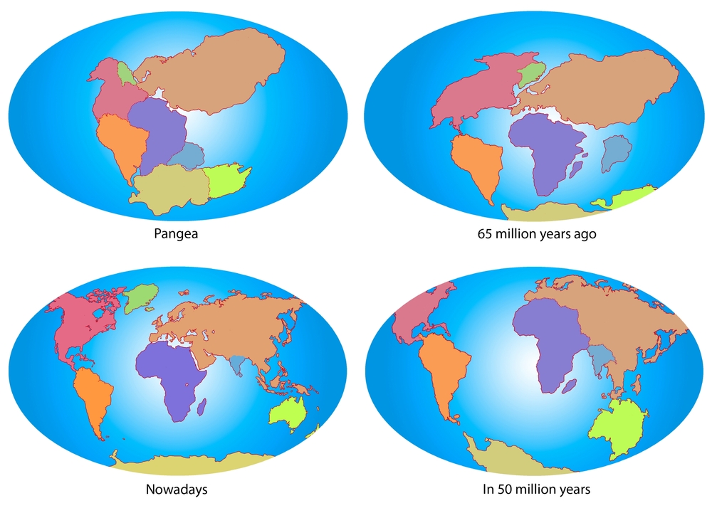
The place you call home may feel permanent, but the ground beneath your feet has been on an extraordinary journey for hundreds of millions of years. Long before cities, countries, or even dinosaurs existed, the land your house now occupies could have been part of a vast tropical coastline, buried beneath an ancient ocean, or sitting thousands of miles from its present location. Those slow but relentless movements shaped the continents we recognize today, although they happen so gradually that they’re impossible to notice during a human lifetime. Now, thanks to a newly upgraded online tool, anyone can finally watch that incredible journey unfold.
Contents
show
Researchers at Utrecht University have unveiled an updated version of Paleolatitude.org, an interactive platform that allows users to trace almost any location on Earth back through 320 million years of geological history. Simply type in a town, city, landmark, or even your own backyard, and the website reconstructs where that piece of land once sat as continents drifted across the globe, mountain ranges formed, and the supercontinent Pangaea slowly broke apart. While it’s undeniably fascinating for curious users, scientists say the tool could also change the way researchers study ancient climates, fossil discoveries, and the evolution of life itself.
The Tool Turns Millions Of Years Into A Few Seconds
Trying to picture Earth’s distant past isn’t easy. Most of us learned in school that the continents were once joined together in a giant landmass called Pangaea before gradually separating into the world map we know today. Beyond that, however, the concept often feels abstract. We hear that tectonic plates move only a few centimeters each year, but it’s difficult to appreciate what that means over hundreds of millions of years.
The updated Paleolatitude.org platform changes that by transforming a complex geological process into something anyone can explore. Instead of reading scientific papers or interpreting complicated maps, users simply search for a location and watch its position change through time. Within seconds, the website reveals how that same patch of land migrated across different climates and latitudes as Earth’s surface slowly reshaped itself.
Whether it’s your hometown, a famous archaeological site, or somewhere you’ve always wanted to visit, the experience gives a completely different perspective on our planet’s history. A place that today experiences cold winters may once have sat near the equator, while land now covered by tropical forests may previously have existed much closer to one of Earth’s poles. Those enormous changes become surprisingly easy to understand when you can actually watch them happen.
For many people, that’s what makes the tool so captivating. It transforms continental drift from a scientific concept into a personal story. Instead of simply reading that continents move, you can see exactly where your own corner of the world has travelled over an almost unimaginable stretch of time.
Scientists Built It For A Much Bigger Reason
Although the website is entertaining enough to lose yourself in for hours, the researchers behind it had a far more ambitious goal than satisfying people’s curiosity. The project was designed to solve one of the biggest challenges facing geologists and paleontologists studying Earth’s ancient history.
When scientists discover fossils today, they aren’t necessarily looking at the environment where those organisms originally lived. Continents have been slowly moving for hundreds of millions of years, carrying rocks, coastlines, and entire ecosystems along with them. That means a fossil uncovered in modern Europe may have actually formed much closer to the equator, while rocks found in one hemisphere may originally have belonged somewhere completely different.
Without accounting for those movements, it’s easy to misunderstand what ancient environments were really like. Researchers trying to reconstruct prehistoric climates or explain how certain species evolved need to know not only when an organism lived, but also where it lived at that point in Earth’s history.
Emilia Jarochowska, a paleontologist at Utrecht University and one of the study’s co-authors, believes the upgraded model represents a major step forward. “With the new model, we have much greater certainty, and our understanding of biodiversity is shifting from one-dimensional, that is, solely over time, to three-dimensional, encompassing space as well,” she explained. That extra dimension allows researchers to examine how life changed not just through different geological periods, but across an ever-changing planet.

Reading Earth’s Ancient Magnetic Fingerprints
One of the most remarkable aspects of the project is how scientists actually know where continents were hundreds of millions of years ago. After all, there were no satellites, maps, or GPS systems recording Earth’s geography during the age of the dinosaurs.
The answer lies hidden inside ancient rocks.
Many rocks contain tiny magnetic minerals that behaved like microscopic compass needles when the rock first formed. At the time they hardened, those minerals aligned themselves with Earth’s magnetic field, effectively recording the latitude where the rock originated. That magnetic signature remained locked inside the rock long after continents began their slow journey across the planet.
Today, researchers can measure those ancient magnetic orientations using highly sensitive instruments. By comparing thousands of rock samples collected around the world, scientists can reconstruct where continents once sat and how they gradually shifted over hundreds of millions of years. This branch of geology, known as paleomagnetism, has become one of the most important tools for understanding Earth’s deep history.
The updated Utrecht Paleogeography Model improves those calculations by incorporating years of newly collected geological data. It also includes information from smaller tectonic plates, mountain-building regions where land has been compressed together, and updated models showing how Earth’s magnetic poles themselves wandered through time. Combining all of that evidence produces one of the most accurate reconstructions of ancient Earth currently available.

One Fossil Site Suddenly Made Perfect Sense
The researchers highlighted one remarkable example that demonstrates exactly why the new model matters.
Near the Dutch town of Winterswijk, a quarry contains fossils dating back around 245 million years. The site preserves the remains of plants and marine animals that once lived together in an environment unlike anything found in the modern Netherlands. For decades, scientists recognised that something about the fossils seemed unusual.
Many of the species appeared better suited to climates similar to today’s Persian Gulf than to northern Europe. The obvious explanation was that Earth itself was generally warmer during that period. While that certainly played a role, the updated model revealed another crucial piece of the puzzle.
When researchers reconstructed the ancient position of the fossil site, they discovered that the region wasn’t located anywhere near its present latitude. Around 245 million years ago, the land that would eventually become the Netherlands actually sat much closer to the latitude occupied today by modern Arabia. In other words, those organisms weren’t living in a surprisingly warm part of Europe. Europe simply wasn’t where it is today.
That discovery demonstrates why reconstructing ancient geography is so important. A fossil only tells part of the story. Understanding exactly where that organism lived helps scientists build a much more accurate picture of prehistoric ecosystems, climate zones, and the environmental pressures that shaped evolution.
Researchers Tested The Tool On Thousands Of Ancient Fossils
To demonstrate just how useful the updated platform can be, the research team went beyond simply tracking the movement of continents. They used the model to investigate one of the biggest questions in paleontology: how biodiversity changed across different parts of the planet during Earth’s distant past.
The scientists analyzed an enormous database containing roughly 34,000 marine fossils dating back to the Late Jurassic Period, when dinosaurs ruled the land and vast oceans covered much of the planet. Instead of studying where those fossils are found today, the team calculated where each organism actually lived when it died millions of years ago.
That distinction is far more important than it might seem. Continental drift has carried rocks across thousands of kilometers since those fossils were first buried. Looking only at their present-day locations can produce a distorted picture of ancient ecosystems. By rewinding the continents to their original positions, researchers could reconstruct prehistoric biodiversity far more accurately than ever before.
The updated model also incorporates sophisticated statistical methods that account for uncertainty in fossil ages and geological reconstructions. This gives scientists much greater confidence when comparing biodiversity between different regions and geological periods, allowing them to distinguish genuine biological patterns from gaps in the fossil record.
Understanding Ancient Extinctions Could Help Explain Today’s Climate Crisis
Although the website invites people to explore the past for fun, its greatest scientific value may lie in helping researchers understand the future.
Earth has experienced several mass extinction events during its history. Some were triggered by rapid global warming, others by cooling, volcanic eruptions, asteroid impacts, or dramatic environmental change. Each event reshaped life on the planet, wiping out countless species while allowing others to flourish.
Scientists are still trying to understand why certain regions became ecological disaster zones while others acted as refuges where life managed to survive. By reconstructing the exact positions of continents during those periods, researchers can begin answering questions that were previously impossible to investigate with confidence.
Jarochowska explained that the updated model allows scientists to explore issues such as which latitudes became uninhabitable first during periods of rapid climate change, which regions provided safe havens for surviving species, and whether organisms migrated, adapted, or ultimately disappeared altogether. Those insights don’t just improve our understanding of ancient history. They also provide valuable context for studying how modern ecosystems may respond as today’s climate continues to change.
While Earth’s current environmental challenges are unfolding far more quickly than continental drift itself, the fossil record remains one of the best archives scientists have for understanding how life reacts when the planet changes.
The Website Is Built For Scientists And Curious Minds Alike
One reason the updated platform stands out is its accessibility. Geological reconstruction tools have traditionally been designed for researchers, often requiring specialized software and technical expertise to operate. Paleolatitude.org takes that complex science and presents it in a way almost anyone can understand.
Visitors only need to type in a location to begin exploring. Within moments, the platform reconstructs where that land once existed, showing how it migrated across the globe over hundreds of millions of years. Watching continents slowly separate and collide makes the immense scale of geological time feel surprisingly tangible.
For professional researchers, however, the website offers much more than an interactive map. Users can upload large datasets, export graphs, and calculate paleolatitudes for thousands of locations simultaneously. Those capabilities make the platform valuable for studies involving fossils, ancient climates, geological formations, and the evolution of biodiversity.
Some of the tool’s key features include:
- Tracking the latitude of almost any location over the past 320 million years.
- Exporting graphs and datasets for scientific analysis.
- Uploading large collections of geological or fossil data for bulk calculations.
- Using updated tectonic plate reconstructions that include smaller continental fragments.
- Accounting for changes in Earth’s ancient magnetic poles to improve accuracy.
By combining a user-friendly interface with research-grade data, the platform bridges the gap between public curiosity and professional science.
Sources:
- Van Hinsbergen, D. J. J., Vaes, B., Boschman, L. M., Lom, N., Van De Lagemaat, S. H. A., Advokaat, E. L., De Baar, S., Fraters, M. R. T., Paridaens, J., & Jarochowska, E. B. (2026b). Paleolatitude.org 3.0: A calculator for paleoclimate and paleobiology studies based on a new global paleogeography model. PLoS ONE, 21(4), e0346817. https://doi.org/10.1371/journal.pone.0346817